Frequently Asked Questions
Product Overview & Core Technology
What is AEye's 4Sight™ M and how does it support Automated Incident Detection?
AEye's 4Sight™ M is a software-defined lidar sensor designed to enhance Automated Incident Detection (AID) for highways, bridges, and tunnels. It leverages AEye’s Intelligent Sensing Platform to provide faster, more accurate, and reliable perception up to 350 meters, complementing cameras, radars, and loops in existing AID applications. This enables improved data collection speed and quality for real-time incident detection and response. [Source]
How does AEye’s software-defined lidar differ from legacy sensors like cameras and radars?
Unlike cameras and radars, which struggle to adapt to changing traffic and environmental conditions, AEye’s software-defined lidar delivers highly accurate, real-time data in all lighting and weather conditions. This adaptability ensures reliable detection of traffic disruptions and incidents, overcoming the limitations of legacy sensors. [Source]
What are the main benefits of using AEye’s 4Sight™ M for smart infrastructure?
4Sight™ M enables faster, more accurate perception up to 350 meters, extends the sensing capabilities of existing AID applications, performs reliably in all lighting and weather conditions, and provides high-quality data for highway, bridge, and tunnel monitoring. It is easy to deploy, low maintenance, and supports flexible integration. [Source]
What is a software-defined lidar sensor?
A software-defined lidar sensor is a lidar system whose performance and features can be customized and updated via software, rather than requiring hardware changes. This allows for rapid adaptation to new use cases, future-proofing, and ongoing improvements through over-the-air updates. [Source]
Features & Capabilities
What features does AEye’s 4Sight™ M offer for Automated Incident Detection?
4Sight™ M offers a library of unique performance modes optimized for AID, highest depth information data quality, up to four returns for improved data in adverse conditions, ultra-long-range detection (up to 350m per sensor), and flexible integration for various infrastructure scenarios. [Source]
How does 4Sight™ M perform in adverse weather and lighting conditions?
4Sight™ M is engineered to perform reliably in all lighting, weather, and environmental conditions, ensuring consistent and accurate perception for incident detection regardless of rain, fog, or darkness. [Source]
What types of incidents can AEye’s 4Sight™ M detect?
4Sight™ M supports detection of wrong-way vehicles, objects on the roadway, road congestion and occupancy levels, vehicle type classification, stopped vehicles, pedestrians and bicycles on the roadway, and vehicles under speed or overspeed. [Source]
How many lanes can 4Sight™ M monitor simultaneously?
4Sight™ M, combined with its perception engine, can monitor up to 12 lanes of highway traffic at distances up to 300 meters, providing comprehensive coverage for large-scale infrastructure. [Source]
What is the maximum detection range of 4Sight™ M?
Each 4Sight™ M sensor can detect objects up to 350 meters, making it suitable for highway, bridge, and tunnel monitoring applications. [Source]
What makes AEye’s lidar solution easy to deploy and maintain?
4Sight™ M is designed for easy operation, simple installation, low maintenance costs, and straightforward commissioning, reducing the complexity and total cost of ownership for infrastructure operators. [Source]
How does AEye’s solution support flexible integration?
4Sight™ M offers high versatility regarding sensor height, pitch angle, number of lanes, traffic density, and types of data to extract, making it adaptable to a wide range of infrastructure configurations. [Source]
What is the advantage of having up to four returns in lidar data?
Having up to four returns allows 4Sight™ M to collect more comprehensive data in adverse weather and environmental conditions, improving perception accuracy and reliability for incident detection. [Source]
How does AEye’s solution help avoid development uncertainty?
As a software-defined lidar sensor, 4Sight™ M can be optimized for specific AID application needs through software updates, reducing the risk of obsolescence and ensuring alignment with evolving requirements. [Source]
Use Cases & Applications
What are the main use cases for AEye’s 4Sight™ M in smart infrastructure?
4Sight™ M is used for wrong-way detection, object warning, road congestion and occupancy monitoring, vehicle type classification, stopped vehicle detection, pedestrian and bicycle detection, and speed monitoring on highways, bridges, and tunnels. [Source]
How does AEye’s lidar improve safety and efficiency in Automated Incident Detection?
By providing faster, more accurate, and reliable perception, AEye’s lidar reduces incident response and clearing times, minimizes road congestion, and improves overall safety and operational efficiency for transportation infrastructure. [Source]
Can AEye’s 4Sight™ M be used alongside existing camera and radar systems?
Yes, 4Sight™ M is specifically designed to complement cameras, radars, and loops in existing AID applications, enhancing the overall perception and data quality for incident detection. [Source]
What types of infrastructure projects benefit most from AEye’s lidar solution?
Highways, bridges, tunnels, and smart city infrastructure projects benefit from AEye’s lidar, especially where real-time incident detection, congestion monitoring, and safety improvements are critical. [Source]
How does AEye’s lidar support pedestrian and bicycle safety?
4Sight™ M can detect pedestrians and bicycles on the roadway, enabling timely alerts and interventions to prevent accidents and improve vulnerable road user safety. [Source]
How does AEye’s lidar help with wrong-way vehicle detection?
4Sight™ M’s real-time perception engine can accurately detect vehicles traveling in the wrong direction, enabling rapid response to prevent collisions and improve highway safety. [Source]
How does AEye’s lidar contribute to congestion and occupancy monitoring?
4Sight™ M provides high-quality, real-time data on road congestion and occupancy levels, supporting traffic management and enabling more efficient use of infrastructure resources. [Source]
Can AEye’s lidar classify different types of vehicles?
Yes, 4Sight™ M supports vehicle type classification, enabling infrastructure operators to distinguish between different vehicle categories for more granular traffic analysis and management. [Source]
How does AEye’s lidar detect stopped vehicles?
4Sight™ M’s perception engine can identify stopped vehicles on the roadway, enabling rapid incident response and reducing the risk of secondary accidents. [Source]
Technical Documentation & Resources
Where can I find technical specifications for AEye’s 4Sight™ M?
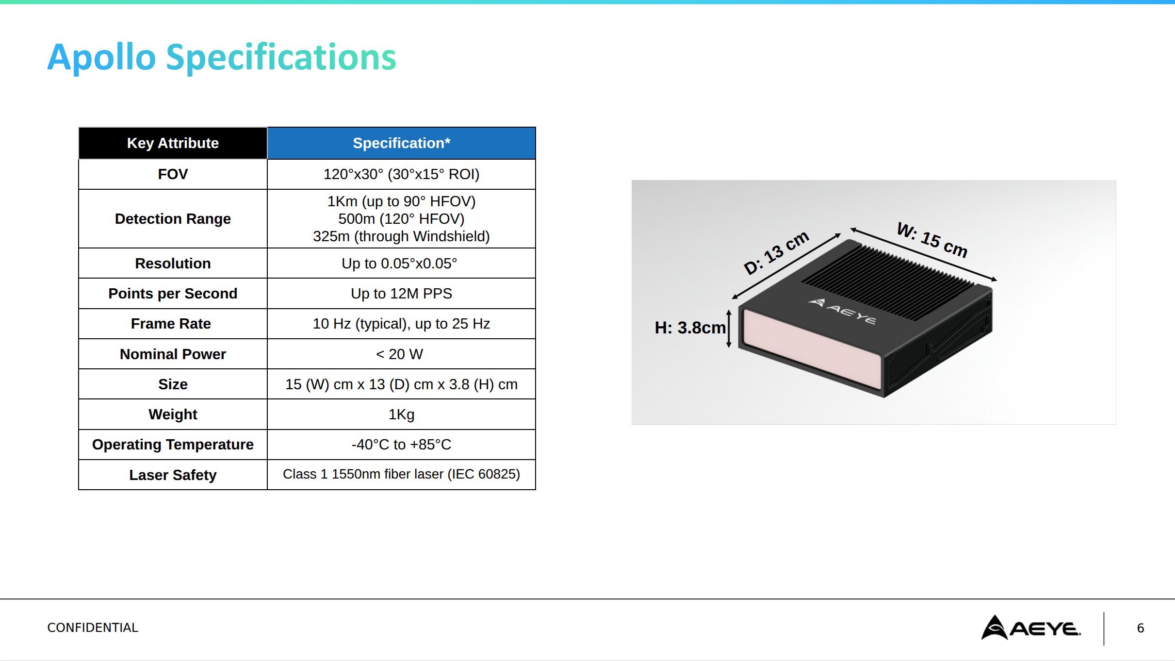
Detailed performance specifications for AEye’s Apollo solution, which shares core technology with 4Sight™, can be downloaded from this link. For more resources, visit AEye’s Resources Page.
Are there case studies demonstrating AEye’s lidar in real-world infrastructure projects?
Yes, AEye provides case studies such as the Lidar Case Studies for ITS Use Cases, which showcase the application of AEye’s lidar in Intelligent Transportation Systems and smart infrastructure projects. [Source]
What technical resources are available to help with implementation?
AEye offers specification sheets, white papers, validation reports, and case studies to support technical evaluation and implementation. These resources are available on the AEye Resources Page.
Does AEye provide validation testing tools for its lidar solutions?
Yes, AEye provides validation testing tools to simplify the testing and validation process, ensuring the product meets specific application requirements. [Source]
What training and support does AEye offer for new customers?
AEye offers comprehensive training resources, including documentation, tutorials, and hands-on training sessions, as well as direct technical support to ensure smooth onboarding and implementation. [Source]
How easy is it to integrate AEye’s lidar with existing infrastructure systems?
AEye’s solutions are designed for ease of integration with existing systems, ensuring minimal disruption and a quick start for infrastructure operators. [Source]
What is the typical implementation timeline for AEye’s lidar solutions?
While the exact timeline varies by project, AEye’s focus on ease of integration, technical support, and validation tools ensures a smooth and efficient onboarding process for most infrastructure deployments. [Source]
Competition & Differentiation
How does AEye’s lidar compare to traditional lidar solutions from competitors?
AEye’s lidar stands out with its software-defined architecture, dynamic scan patterns, adaptability to challenging environments, and future-proof design with over-the-air updates. These features provide greater flexibility, scalability, and long-term value compared to traditional fixed-scan lidar systems. [Source]
What are the unique advantages of AEye’s lidar for Automated Incident Detection?
Unique advantages include dynamic scan patterns, high-resolution and long-range detection, adaptability to adverse conditions, software-defined customization, and ease of deployment and integration. These features are specifically optimized for AID applications. [Source]
How does AEye’s lidar address the limitations of legacy sensors in AID applications?
Legacy sensors like cameras and radars are limited by environmental conditions and lack adaptability. AEye’s lidar provides reliable, high-quality data in all conditions and can be customized for specific AID needs, overcoming these legacy limitations. [Source]
What makes AEye’s lidar future-proof compared to other solutions?
AEye’s software-defined architecture allows for over-the-air updates and ongoing customization, ensuring the technology remains relevant and adaptable to evolving infrastructure needs without requiring hardware changes. [Source]
Who are some notable customers and partners using AEye’s lidar technology?
Notable customers and partners include Continental (automotive production), Sanmina Corporation (manufacturing), and NVIDIA (integration with autonomous vehicle platforms). These partnerships demonstrate AEye’s industry credibility and broad adoption. [Source]
Industry Applications & Case Studies
Which industries are represented in AEye’s lidar case studies?
Industries include automotive, trucking, smart infrastructure, aviation, defense, rail, and logistics, demonstrating the versatility of AEye’s lidar technology across diverse real-world applications. [Source]
Are there real-world examples of AEye’s lidar improving safety and efficiency?
Yes, case studies such as A Pedestrian in Headlights and Flatbed Trailer Across Roadway demonstrate how AEye’s lidar enables early detection and rapid response, improving safety and operational efficiency. [Source]
How does AEye’s lidar help with Intelligent Transportation Systems (ITS)?
AEye’s lidar provides accurate, real-time data for ITS applications such as automated incident detection, highway monitoring, and smart intersection management, supporting safer and more efficient transportation networks. [Source]
What are the broader benefits of deploying lidar in urban infrastructure?
Deploying lidar in urban infrastructure helps build smarter, more connected systems that ease congestion, reduce accidents, improve safety, and enhance the overall quality of life for citizens. [Source]
How can lidar improve urban transportation systems?
Lidar can enhance smart intersection management, pedestrian safety, traffic data collection, emission reduction, emergency response, automated tolling, and prioritization of pedestrian and cyclist safety at intersections. [Source]
Why is lidar considered the next big step in sensor technology for ITS?
Lidar is the only true deterministic sensor that precisely identifies and locates objects in three-dimensional space, providing highly accurate measurements for object detection, classification, and trajectory analysis—essential for reliable ITS applications. [Source]
How does solid-state lidar open up new opportunities for smart cities?
Solid-state lidar enables advanced sensing capabilities for urban infrastructure, improving traffic management, safety, and the development of intelligent transportation systems through its precision and reliability. [Source]


